NORTHWARD DRIFTWOOD SOLDIER
Two weeks in California, Oregon, Washington, British Columbia, and Idaho
In July of 2001 I took my motorcycle and an old beat-up camera from Oakland, CA, up to Spokane, WA, and beyond. My mission: to visit the house and land on the side of Dunn Mountain where my father had lived from 1979 - 1985. I had spent summers and Christmas there for seven years, walking, shooting, building, haying, swimming, visiting, horseback riding and driving through a dream which I was too young to fully appreciate. As it turned out, our friend and neighbor Eleanor was still living on the mountain. She, her friend Philip, and the land itself were to reveal themselves as gracious and wonderful beyond my wildest hopes.
This is a rather long-winded account, and those without time to burn and the willingness to burn it may wish to just peruse the pictures and read their captions. I wrote it long in an attempt to capture the memories, for myself, of my best and most adventurous road trip yet. Hope you enjoy it too!
|
NORTHERN CALIFORNIA
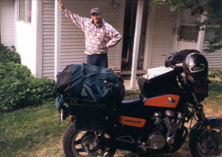
I left home on Friday, July 13th, determined to make time. I wanted to be in Colville, northeast Washington, by Sunday evening for Eleanor's dinner party, so I resisted my usual urge to dawdle endlessly. But I didn't leave til noon, heading north on I-80, I-505, and I-5, so the heat was terrible, 95+ and cloudless.
By the time I reached Red Bluff I was ready for a serious break. Meandering (dawdling) on the slow roads I circled Red Bluff, which made a good if indistinct impression on me. I stopped for a swim in the river, probably the Sacramento, swimming in my clothes to try to beat the heat. When I returned to the bike there was a party going on in the parking lot not 30' from my spot, Mexican farm workers who had just finished work for the day.
Continuing north to Redding, I stopped at the Greyhound station where my sister and I had languished so many times on our way to Spokane. Unlike the other stations, the remnants of which I would find later on in Klamath Falls, Bend, and Pasco, the Redding station was in beautiful shape and open for business. (The restaurant was deceased, however.)
Heading north on 5, the interstate winds through a forested valley, the scenery fantastic. Those little dotted lines on the map are well placed. Shasta City was pretty, but very touristy, nestled under the west side of the mighty Mt. Shasta. The country in these parts is hilly but not terribly high, so the 14,000' Mt. Shasta (and all the other extinct volcanoes in the chain heading north from Lassen, including Hood and Rainier) seems to tower above the surrounding landscape. Awesome.
|
|
|
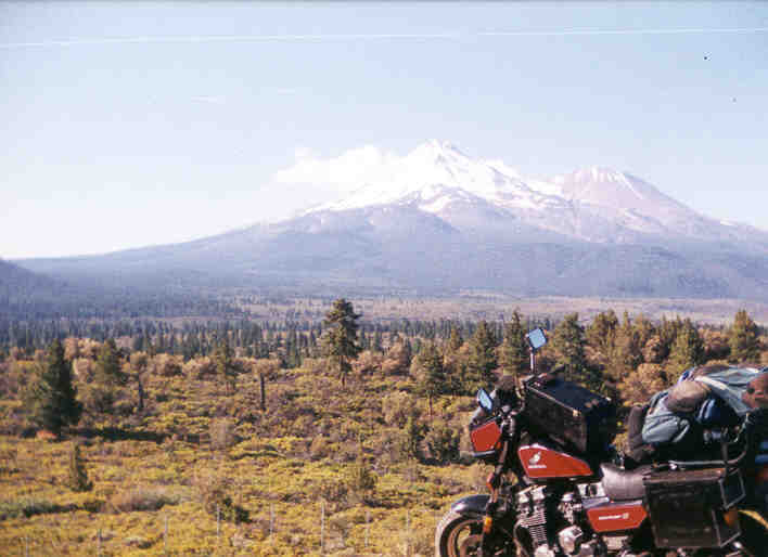
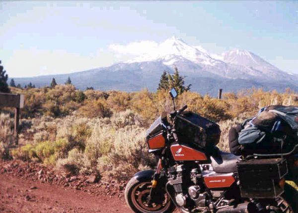
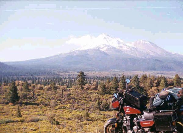
Two views of the extinct volcano Mt. Shasta from the north. Unlike the west side, which you see from I-5, the "back" side feels like eastern-Sierra high desert. There are a bunch of okay dirt roads and fine wilderness camping possibilities. The view of Shasta is amazing. Not obvious from this photo is the fact that Shasta towers 10,000 feet above the surrounding landscape.
|
At the town of Weed (nice looking town if I recall) I departed I-5 for US97, which goes around the north end of Shasta. A few miles down a dirt road I camped, not exactly welcoming another party that arrived as I was turning in to bed. (I started and revved my engine so they'd know I was there, but they didn't seem to care. Oh well, at least they left first thing in the morning.) With me not much behind them, heading for the Oregon border and stopping for the occasional (awesome) photo of Shasta.
|
CENTRAL OREGON
Heading north, I entered Oregon and arrived in Klammath Falls, a workmanlike but still somewhat charming town that seemed to be in the middle of a downtown renewal. The old Greyhound station was a derelict at the unrenewed end of town, but at least it matched my memories. (The new station is in the back of a restaurant just north of town.) I stopped in the town park, on the Klammath River. There were swans, but the water was filthy. Apparently there was a political ruckus in progress regarding an endangered fish and the local farmers competing for the water in Upper Klammath Lake. (Poster: "Without water, no hops; without hops, no beer!")
Gas in Oregon was very cheap, but you couldn't pump it yourself. Well, for motorcycles you could, but the attendant had to come out and enable the pump. The 50-something attendant just north of Klammath Falls filled me in on local politics, history, and gas lore as I wolfed down a breakfast corndog. Then north along side the huge lake, wow. And the brine flies liked it too.
The country between Klammath Falls and Bend is flat and forested, with mountains and the monolithic cones of extinct (I hope) volcanoes to the west. The traffic was bad, too much for the sparsely populated region. Crater Lake is up in those mountains to the west, and it was a Saturday, so maybe that's where some of the people were heading.
I figured I'd better smell some roses, so I took the long way known as the Cascade Lakes Highway. Lovely, especially my stop at a meadow/stream that seemed much like those found much higher but farther south in the Sierras. Alpine. While parked there, the couple I had spoken with an hour before back on US97 drove by and beeped, a sweet stop in every way. And I played cat and mouse with another touring rider on old Japanese hardware (82 Suzuki GS750 perhaps). Turns out he was returning to Portland from Arizona. Boy his tires looked skinny from behind!
|
|
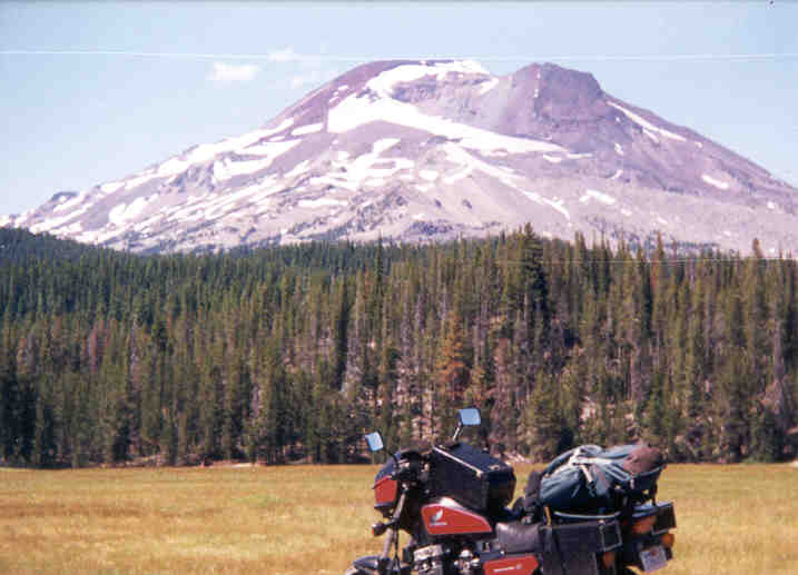
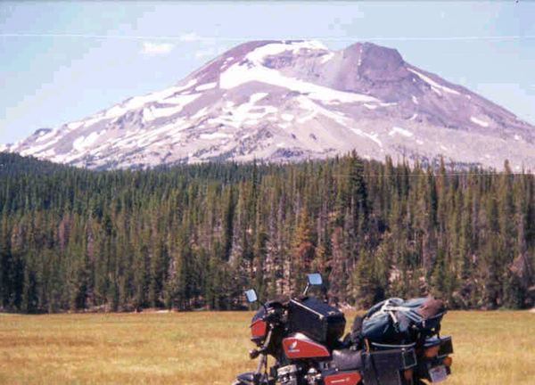
A view from the Cascade Lakes Highway, north of Crater Lake. This area is very beautiful. If Crater Lake looks like this then I can see why it's said to be so damn crowded!
|
Next stop, the city of Bend. An outdoorsperson's paradise, Bend was beautiful (like Chico, CA but in a mountain/forest setting) but somewhat overwhelmed by growth. A summer festival was in full swing, and I never could find the old (still functioning?) Greyhound station. Nor can I remember it from the 80's. Anyway, I'm back on US97 and heading north, through Redmond and Madras. Somewhere I found a burrito, because while eating at the rest stop north of Madras an '85 BMW R80GS pulled up to chat for a while. Jim, a 60-something high school teacher, was halfway between his home in Anchorage and his visit to Boise or some such. I was mighty impressed with his old machine, loaded for bear and with his wife having been dropped off back in Bend for a lace convention.
I stayed on US97 and thus missed The Dalles, one of our old bus stops. This is wind country, with rolling golden hills and many wildfires burning. Shaniko, a very interesting little old-west ghost town. When I reached the Columbia, the REAL wind began, good God! The bus had traveled above the Columbia here over to 395 and Umatilla, but I fled up out of the gorge, north into Washington.
|
EASTERN WASHINGTON
Now dark and tired, I departed the highway at Goldendale and flailed around looking for a place to crash. Heading east on a minor road, I lucked into a spot with no fence (in the morning I found it was down and I'd ran over it) and had a lovely night of trespass camping. The next day I passed through the villages of Cleveland (great cemetery) and Bickleton (one store/cafe, with eight BMWs parked out front in the cold morning air). Ironically, that evening I was to have dinner with a family that had lived in tiny Bickleton for ten years! The country here was rolling brown hills, not unlike the Bay Area, but a good deal higher as I found when I descended into the Pasco River valley and civilization. Or population.
The valley is an agricultural region, now focused on vineyards. I discovered this almost immediately, because where there's labor-intensive agriculture in the West, there's poor immigrant labor from south of the border. The whole valley felt a bit squalid to me, not unlike California's Central (San Joaquin) Valley. Importing cheap foreign labor, paying slave wages, and dividing labor along racial lines, creates social problems. That's the way I see it, and having grown up with it in California, I don't really like it.
The Tri-Cities (Pasco/Kennewick/Richland) were no great prize. The boarded-up Greyhound station was next to a homeless shelter, on the edge of Pasco's busy and largely Hispanic downtown. I had lunch at a seedy gas station, along with fuel, air for the tires, and Seventies Rock coming from the gas pumps. Not a bad way to see a town.
Heading north on I-395, I rediscovered my loathing of superslab until I reached Ritzville, which I liked. A hardware store provided me with a quart of oil. A blues festival had been through the night before, and the old downtown was still hung over. Heading north and east, I was back in hog heaven -- the rolling wheat country stunning. The little town of Harrington was picture perfect (well almost), filling my mind with thoughts of retirement and golf. Really.
The county seat of Davenport wasn't quite as nice. Though the town and the route north were very pretty, the area was a bit overwhelmed by summer Sunday traffic between Spokane (to the east) and Lake Roosevelt (to the north). Though things were jumping, literally, at the airport. Heading north, I managed to avoid the traffic cops and made it to historic Fort Spokane, which was nice but mostly gone. The lake was zoo-like with boaters, so I pushed on north through the Spokane Indian Reservation (quiet except for the casino) and paralleled the lake through the quaint little villages of Fruitland and Hunters. Stopping for provisions at the store that was Cedonia, the proprietor gave me directions, and let me make a phone call to Eleanor. She quickly recovered from her surprise at my imminent arrival (the time of which had been uncertain), and thus began my journey through my old summer stomping grounds.
|
COLVILLE AND FAR NORTHEASTERN WASHINGTON
The next five days were very emotional for me. Coming back after fifteen years, and finding everything (despite my fears) to be mostly unchanged, and mostly fantastic, had me close to tears of joy. (Quite out of character!) The country was far more beautiful and lush than I had remembered, and all the people I met wonderful.
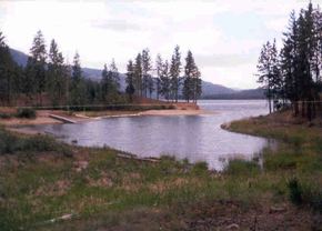
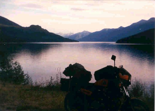
I stopped in the settlement (just a post office really) of Gifford for a swim. We had come here many times on hot summer days, and the cove (see picture below) was just like I remembered. There were even some substantial, friendly, redneck locals swimming. Walking out to the end of the point on the south side of the cove and seeing the ferryboats crossing the lake/river was like being home again.
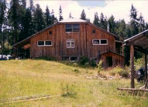
Heading east and inland on Summit Valley (Gifford/Addy) Road, there seemed to be a bit of new development, but the valley was gorgeous. Turning north onto Old CC (Dunn Mountain) Road, there was some new development at first, but then things quieted down. That old farmhouse is still there, but there's a newer house nearby. Over the summit and down on "our" side of the mountain, new construction was minimal. Most of the old houses were still there: Del and Christy's (new horse ring across the road), that combo house/trailer where those really nice Born Agains lived, and Pudd and Alita's spread (bunkhouse across the road). The house at the "Y" with Naff Road had burned recently, but the others south of us on Old CC were seemed unchanged. There was a house and tall fence in place of the trailer that used to be our northern neighbor. (I only discovered the house, and horse barn, later when hiking and lost.) And then there was our house.
Our old house, which my father (and I) had built twenty-three years before, stood there looking like time had no meaning. There were changes, certainly: a new deck or two, a hot tub (!), and a new store-bought horse barn in place of our old one. The in-law house also looked fine, also with a new barn. Eleanor's house, which was somewhat based on ours, was in great shape, now with a glassed-in deck and a big basement.
The land was lush and beautiful beyond words. Apparently our previous years living there had been during a period of drought, but now all was green. It was also cold, unseasonably so, which had made my journey more pleasant. (You can always put more layers on, but...) Their garden, surrounded by a 8' deer fence, was incredible. Though the level parts of the timber company land behind the house (350 acres of it) had just been devastated by the once-every-thirty-year cycle of slash and don't burn logging, none of that was visible from the house. All my favorite house-sized climbing rocks were unscathed and wonderful.
I arrived to a dinner party being thrown by Eleanor and Philip, complete with health food and three other hippie couples. It was like stepping twenty years back in time to our homesteading years. Fantastic!!! (Glad I had swam an hour before.)
The next four days and four nights were awesome. I tried to retrace all of my old steps through the woods and stopped to pay homage to the three giant rocks near the house. Huckleberries and wild strawberries were harvested, torrential rain witnessed, local property lines ignored. Many of my memories were demolished with the logging, but many more remained.
|
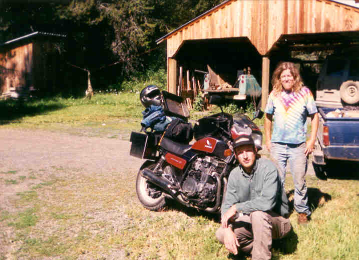
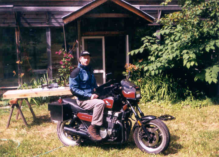
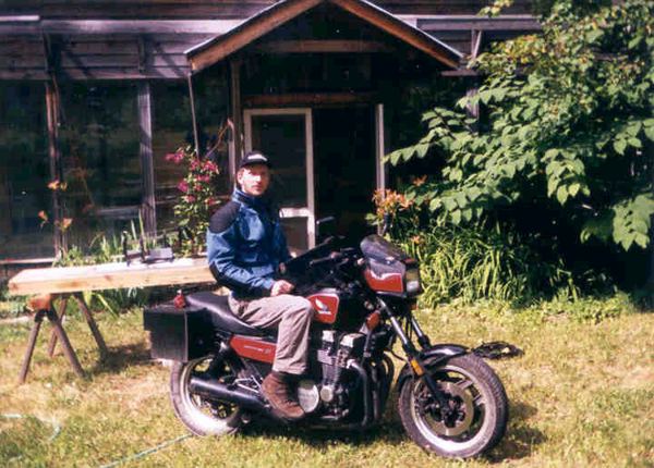
|
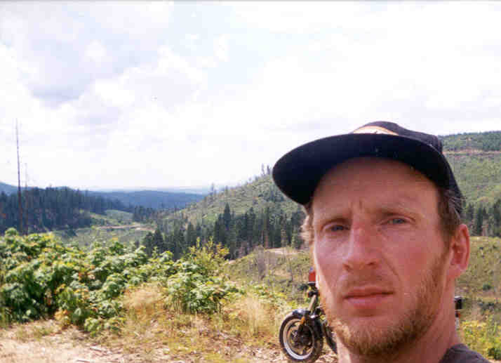
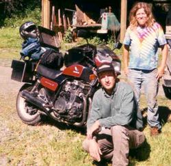
Yours truly, mugging for the camera in my standard summer touring duds. The house, half an hour south of Colville, WA, belongs to my kind host and long-ago neighbor Eleanor.
|
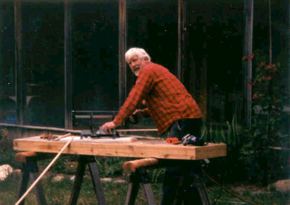
I spent a lot of time hanging out with Philip, and eating their food. Philip had been something of a hermit, living an even more isolated life, until Eleanor rescued him from another mountain and brought him to this one. His new job: house hermit, handyman, and builder. (I should mention that he also goes to the coast for several months a year to earn some bread doing carpentry.) We went to town together, and even played a little tennis along with his friend Gary. Sadly, tennis in big hiking boots sucked. But the view from Colville High School, up on a bluff near the airport and golf course, was fantastic.
Eleanor was also the consummate hostess. She looked much as I had remembered her from fifteen years before. I had been very surprised that she was still living on the mountain, because that's not an easy place call home, especially in winter. But apparently she grew up in the pine barrens of New Jersey, so to her isolation felt like home. And my timing was fortunate -- it being summer, she was off from her job as a teaching assistant at the high school. And she was only one year from retirement (I think), with plans of travel after that. Hopefully she'll keep the land, I'm sure her two sons would agree.
Town was really cool. Main Street seemed to be in fine shape, with very few of the dead stores that one often sees in "historic downtowns". The city park was beautiful, and also crowded with summer users. The old Natural Foods Co-op was still there and little changed, and still struggling. Though a few big-box stores (Wal-Mart, etc) had sprung up at the north end of town, the resultant retail havoc seemed minimal.
I also rode around a bit. Up Naff road (wow), over to Addy (the old store is dead, there's now a bigger one at the gas station on 395), through Swede Valley (west of Addy), etc. Bodacious.
On my last night I climbed the mountain and camped at the top of the northern, lower peak. Getting up, and back down, was very difficult, partly due to the logging devastation. Though I had only really climbed the mountain once before, I thought my old route would have been more helpful. Fortunately Philip had given me some hints. Along the top there are logging roads, many in good shape, so there must be some good ways up. Possibly fenced. At any rate, the views (Colville, Naff Valley, Addy and Chewelah, and across the hidden Columbia to the Colville Indian Reservation) were majestic. Seemingly infinite forests, including some clearings that seemed to be returning to woods.

|
|
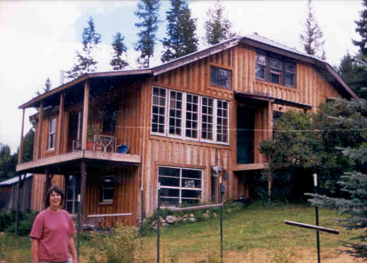
|
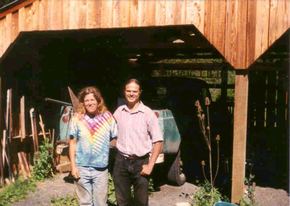
My dad's old house, with long-ago neighbor Eleanor.
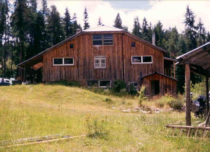
|
Same house, different angle, no Eleanor.
|
|
|
|
Eleanor's fab beau Philip, a prince among men.
|
The cove where we used to swim at Gifford on Lake Roosevelt (Columbia River).
|
|
But all good things must end, so I hit the road again. (Old Afghan saying: "Fish and guests begin to stink after three days".) Heading to Colville for a last look, I wasn't sure where to go next. The roads west looked fantastic, this far north in Washington the mountains would last all the way to the coast. The Cascades are really something. But the problem was, then I'd be at the coast, in Seattle, right before the weekend. Now, in California, the coasts become a zoo on weekends as all of the city folk (like me) converge. So, I decided to head east, and see what happened.
The first thing that happened was cruising around the east side of town, checking out the auto salvage yard where are friends Dick and Joan (and Karl, Otto, Muriel, and Alan) had lived. Stopping for a map break on a quiet intersection, a 60-year-old man pulled off the road to say hi. His name was Calvin, and he was an ex-special forces, Vietnam War vet, with quite a bit in common with Rush Limbaugh. We had a wonderful conversation over the next hour, and if half the stories he told me were true (Vietnam, Latin America, South America, and charity work) then he'd had quite a life. When he left, he said something to the effect that though we might disagree on much, we both believed that our country needed more order. I totally agreed.
Heading east on the Tiger Highway (great name), I pulled off for the night in the Colville National Forest. The next morning I continued to the little town of Tiger (one gift shop, no gas station, thanks, EPA). Behind said gift shop there was a small, privately-maintained (I think) rest stop. Water bottles filled and visor cleaned, I noticed a sign advising me to "drive the scenic Selkirk Loop" up through British Columbia and back down into Idaho. Right, I thought, as I mounted up and headed south. But then I thought about it as I was riding. Here I am, only 30 miles from Canada, and I'm heading south? Why not go for it? So I did.
The first town I passed was Ione, where I stopped for provisions, breakfast hot dog, and a couple of things from the local health food store. I also talked to a couple of passing bikers, one of whom was riding a big R1150GS out of Moscow, Idaho. Continuing north, the next town was Metaline, very pretty and perched above the river. (As was the highway.) For my last US stop I checked out the giant hydro power station at
BRITISH COLUMBIA
Blah blah blah blah blah
Blah blah blah blah blah
Blah blah blah blah blah
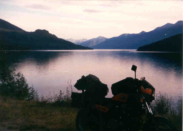
|
|
Late afternoon on Kootenay Lake in British Columbia. The ferry which crossed the lake claimed to be the world's longest free ferry. Seeing the bike teeter on it's centerstand on a moving boat was a bit unsettling.
|
Blah blah blah blah blah
Blah blah blah blah blah
Blah blah blah blah blah
|
NORTHERN IDAHO
Blah blah blah blah blah
Blah blah blah blah blah
Blah blah blah blah blah

|
|
Me, high up in the Clearcut Mountains. (I may have that name wrong.) The mountains of the Famous Potato State are fabulous, but they have had a bit of a problem with clear-cuts that refuse to grow back to forest. Oops, I guess everyone makes mistakes, particularly when you're leasing someone else's (public) land.
|
Blah blah blah blah blah
Blah blah blah blah blah
Blah blah blah blah blah

|
|
|
This is the kind of smile you get after eatin' (and sharin') that elk you've been cooking in the crockpot for twelve hours.
|
You know you're a redneck volleyball player when you mow the court and find the line. Just a joke -- in reality, the line was fairly easy to find because it was a row of crushed beer cans.
|
|

|
|
More kind hosts, Elizabeth and Leroy. They're smiling because we've just had a breakfast of toast, tomatoes, lettuce, and raw garlic. Super yum! (Really.)
|
Things really DO taste better when cooked with stainless steel. Hence, the giant baking pan of Elizabeth's strapped to my bike.
|
|
EASTERN OREGON
Blah blah blah blah blah
Blah blah blah blah blah
Blah blah blah blah blah
|
|
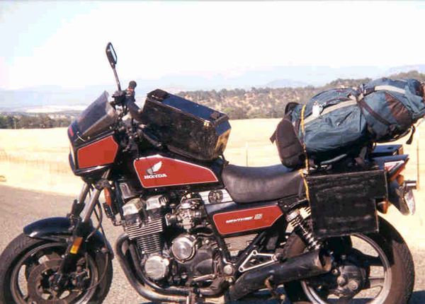
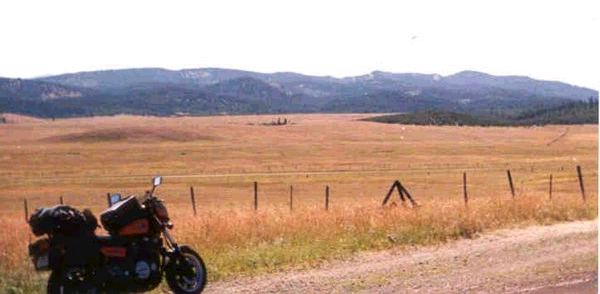
This photo doesn't show much about the area, but it's a great shot of my traveling rig. South-eastern Oregon is high desert, but as you go west the land turns to dry grasslands. In the north-east you find the lovely and often-verdant mountains of the Umatilla and Wallowa-Whitman National Forests, Eagle Cap Wilderness, and Hell's Canyon National Recreation Area.
|
Blah blah blah blah blah
Blah blah blah blah blah
Blah blah blah blah blah
|
NORTHEASTERN CALIFORNIA
Blah blah blah blah blah
Blah blah blah blah blah
Blah blah blah blah blah
|
|
South-west of Alturas, high desert meets eastern Sierra. At least, that was my impression -- I expected Ben and the boys (Hoss, Little Joe, and possibly Adam) to come ridin' through at any moment. Instead, *I* came riding through a swarm of locusts so thick that my wheels crushed dozens. (Back up in Oregon I rode through a much less dense swarm at 60MPH, turns out those suckers really sting when they hit your skin. Bet they liked it even less.)
|
Blah blah blah blah blah
Blah blah blah blah blah
Blah blah blah blah blah
|
[
travelogue |
contact greg ]
|