
iBob Jim Gourgoutis, several members of my bike club, various other longtime and newly met friends and I participated in the San Francisco Randonneurs 200km brevet this past Saturday, January 28th, 2006. Jim and I had met once before last summer, and in true guy/iBob fashion he recognized me by my bike when he spotted my Dave Yates SR near the statue in the Bridge park. Friday's weather started out with a pre-dawn shower and then was at worst mostly sunny all day. Sunday's weather was clear and sunny til mid afternoon. Saturday's weather was like neither day. The ride started at 7am at the south end of the Golden Gate Bridge, and while the roads were wet it was not raining yet. Unlike most brevets I've done, the initial miles were not done in a pack or even a paceline. I pretty much lost sight of anyone else within the first few miles.
The route heads north through Sausalito, Mill Valley and follows a well worn but intermittently signed path through Ross, San Anselmo and Fairfax before hitting rural roads. It was here, west of Fairfax, where the roads changed from urban to rural that the rain began and from that point on it rained far more often than it didn't rain. Just before the last town on Sir Francis Drake Blvd., before it enters the state park there is a disused store that has a large overhang in front. I'm guessing it was once a gas station many decades ago, as there was a planter up on a raised cement island, no doubt where the pumps once were. Several riders pulled over here to set aside the optimism that led them to start the ride with their rain gear safely packed away, instead of on their backs. I hadn't planned on doing more than put on a cycling cap with a brim to keep the rain off my glasses, but in the short time I was stopped the rain came down harder and on came the raingear.
 From here the route goes through the state park (with an option to take a bike
trail set down on an old railroad bed) then climbs the Bolinas Ridge and
goes over to Olema, epicenter of the Quake of 1906. At this point the riders
actually pass over from the North American Plate onto the Pacific Plate, tectonicly speaking, but
it isn't until one has gone past the village of Inverness that the
topography changes.
From here the route goes through the state park (with an option to take a bike
trail set down on an old railroad bed) then climbs the Bolinas Ridge and
goes over to Olema, epicenter of the Quake of 1906. At this point the riders
actually pass over from the North American Plate onto the Pacific Plate, tectonicly speaking, but
it isn't until one has gone past the village of Inverness that the
topography changes.
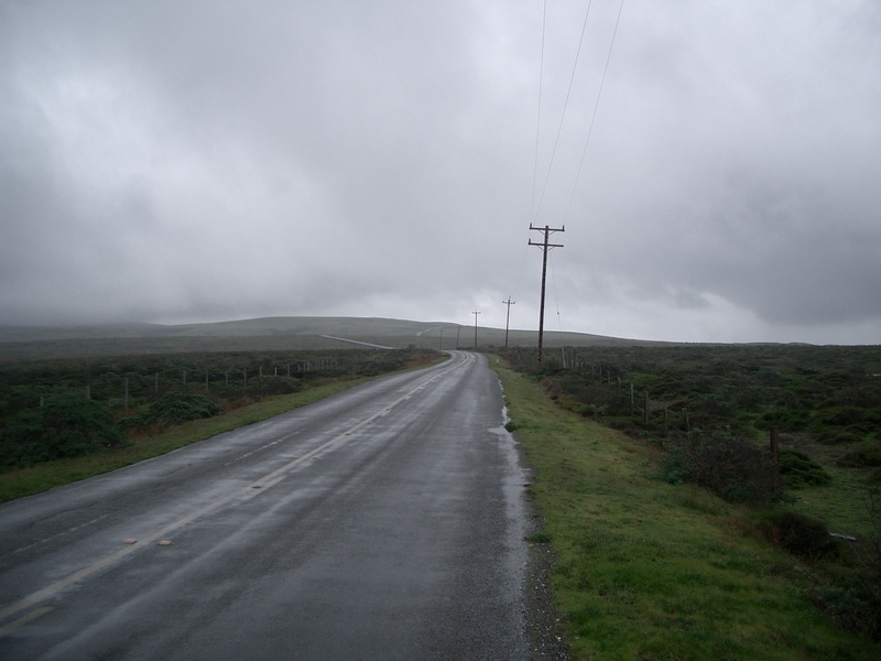
West of Inverness the route heads across the Pt. Reyes penninsula out to the Lighthouse where the first control is located. After climbing the ridge that includes Mt. Vision, pretty much all foliage disappears except the grasses. The photo at the top of the page is very much what the landscape looks like for mile after mile. The road is never flat for more than a few yards as you are climbing one ridge after another. There are some ranches that remain within the National Park boundaries and the roadway within the boundaries of each of the ranches seems to follow a set pattern: cattle guard across the road, mud and manure spread across the road, then another cattle guard. I made it safely across all the cattle guards. Except the last one. That one was a little tricky as it was on an incline, and in spite of being seated and riding at a 90 degree angle to the grating my rear wheel lost traction and I went down hard.

") This ended up being a turning point for me on the ride as after that I just didn't seem to have the same oomphf as before. I lay on the ground for a while waiting for the pain to localize so I would know what had been hurt. Riders returing from the control and those that were coming up from behind helped me get off the grating and off to the side of the road where I could take stock. Nothing broken on me, nothing broken on my bike. Still, I was already sore.
I rolled away from that scene and made the control where I checked in and
ate as the fog blew around the headland there. I was supposed to see
iBob Sterling Hada at this control, but he was working as a docent and
was already on duty elsewhere by the time I arrived. As I left the control
more riders were pulling in, so I knew I wasn't the last rider out there.
This ended up being a turning point for me on the ride as after that I just didn't seem to have the same oomphf as before. I lay on the ground for a while waiting for the pain to localize so I would know what had been hurt. Riders returing from the control and those that were coming up from behind helped me get off the grating and off to the side of the road where I could take stock. Nothing broken on me, nothing broken on my bike. Still, I was already sore.
I rolled away from that scene and made the control where I checked in and
ate as the fog blew around the headland there. I was supposed to see
iBob Sterling Hada at this control, but he was working as a docent and
was already on duty elsewhere by the time I arrived. As I left the control
more riders were pulling in, so I knew I wasn't the last rider out there.
") With the headwind on the way out I had hoped for a nicer ride back
but the reality didn't measure up to the expectations. Rain came off
and on, and sometimes heavy and I stopped in Inverness to "shift
fluids". Inverness isn't that far from the village off Point Reyes Station
but I still felt the need to stop there and get Gatorade and fruit.
With the headwind on the way out I had hoped for a nicer ride back
but the reality didn't measure up to the expectations. Rain came off
and on, and sometimes heavy and I stopped in Inverness to "shift
fluids". Inverness isn't that far from the village off Point Reyes Station
but I still felt the need to stop there and get Gatorade and fruit.
I've done the ride along Highway One next to Tomales Bay many times, but probably never that slowly. The rain, the rain pants I was wearing, the wind and the soreness from the fall were probably slowing me down. The next control, at the far end of an out and back leg was in Marshall and it seemed like that was where the party was. The store had been enlisted to stamp and sign our cards, and we had been enlisted to deplete their stock of clam chowder. This part of Marin on the Highway has several oyster companies and Fish restaurants, and the Marshall store was just one more selling seafood. Some riders had a bottle of beer along with a large cup of chowder, but I just had water and a small cup of the soup. All the tables were full of riders with more waiting to sit so I moved on to let the next group have a spot. Outside I met Bruce who had come over in the car with us. Dan, who had driven us over to the start had left just after I arrived at the control so at that point our car group was pretty near each other in time. That was the last time that we three riders would converge though as on the way back Bruce pulled away and I stopped trying to keep up.
From Nicasio all the way back soreness in my lower back was becoming a problem. It got bad enough several times to make me stop riding and do some stretching. Advil didn't really make a dent in it, but the stops for stretching helped quite a bit. By the time I reached Sausalito it was dark enough to need the reflective leg bands and sash that are required. Normally, on a clear day there would stll have been some daylight to see by. Between Sausalito and the Bridge itself the road is generally an uphill slog and slog is the only way to describe my journey up to the bridge. As it was after dark now, I took the east side walkway over but before I started I had to stop once more, this time to eat. I could see the other side from where I was but I still felt the need to eat first. I heard later that the winds on the bridge were enough to make people walk the whole way across the bridge. As the walkway circumvents the pylons the wind was quite fierce but while I slowed way down, I still rode across.
") I finished the ride in 11 hours and 8 minutes. Before the ride,
I would have been happy enough with 10 hours for the route.
After the ride, 11 hours seems pretty darn good considering the
circumstances.
I finished the ride in 11 hours and 8 minutes. Before the ride,
I would have been happy enough with 10 hours for the route.
After the ride, 11 hours seems pretty darn good considering the
circumstances.
Some observations:
rob hawks
