|
[
Reno |
Nevada |
Utah |
Colorado |
Wyoming/South Idaho/Montana |
Idaho |
Oregon/California
]
COLORADO
|
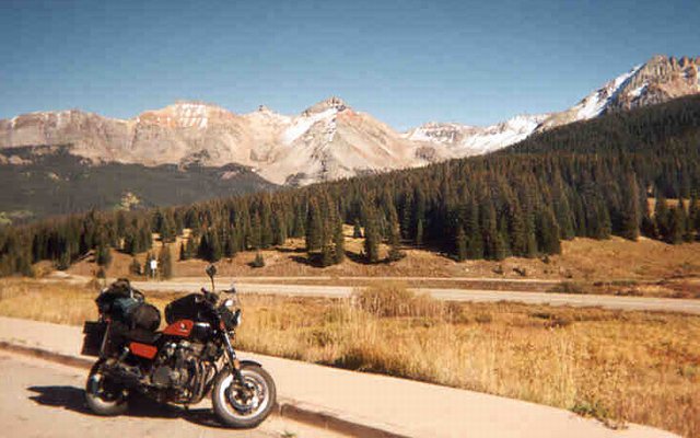
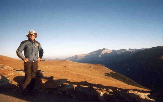
The view from Lizard Head Pass, elevation 10,200', in south-western Colorado. On the other side of those mountains is the resort town of Telluride. Off camera to the right, folks are launching hang gliders. Off camera to the left is a sign warning hikers about possible live explosives used to trigger avalanches in winter.
I crossed from Utah into Colorado on Sept 20th in the early evening. Major differences between the two states were immediately apparent. While stopped for a snack at the town park in Dove Creek, I could see that people were wilder and less self-disciplined, a little like crossing from Wisconsin to Michigan's Upper Peninsula. This area is bean country, famous for pinto and other beans. I also got the impression that this is "Sagebrush Rebellion" country, where the locals have historically been none to pleased with taking orders from Washington. I found the area to be strikingly beautiful, for an agricultural area, and much nicer than California's Central Valley.
I would have preferred to have seen more of this area, but darkness had fallen, and I was thinking about a place to camp. Trouble was, it was hunting season, and it seemed likely that the types of places that I rely upon for dirt-road camping would be occupied. This turned out to be a factor, but even more importantly, I was to learn that the mountains are so steep that dirt roads are surprisingly few. This was to be a major problem for my five nights in Colorado -- too many people, on too few roads, paved and otherwise.
I cruised the town of Dolores, on the edge of the San Juan National Forest. I really liked this town, it felt sort of like a tri-ethnic Everwood meets working-class meets harsh winters. They were having a dance at the high school. Leaving town, I went up into the mountains. With some difficulty and a lot of dissatisfaction, I found a spot next to a dirt road, with large parties (literally) of hunters both up and down the road from me, out of sight but not out of mind.
|
|
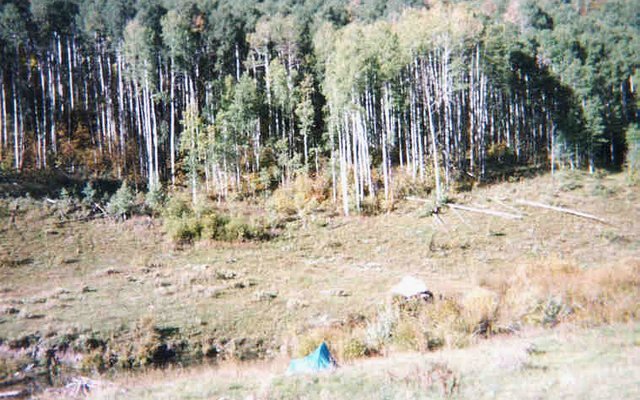
My first night's campsite in Colorado, near the tiny community of Stoner. This is not a great photo, and in fact it was not a great campsite. But as I discovered in the morning, it was actually a pretty good campsite, with aspen forest (pictured) above a beaver pond, and mixed aspen/conifer forest on the other side of the creek. As so often happens, things that seem unfortunate turn out to have wonderful consequences.
In the morning, surprisingly few vehicles drove by, I saw no hunters on foot, and I took two short but very beautiful walks. My first morning in Colorado! Packing up, I returned to Hwy 145 and headed north towards Lizard's Head Pass.
I stopped in the beautiful little town of Rico, elevation 9000', for supplies. This was the site of a major mining boom, way back in the 1890's, I think. How people could have worked and lived at 9000' (or 10,000' or higher) through the winter is beyond me.
|
|
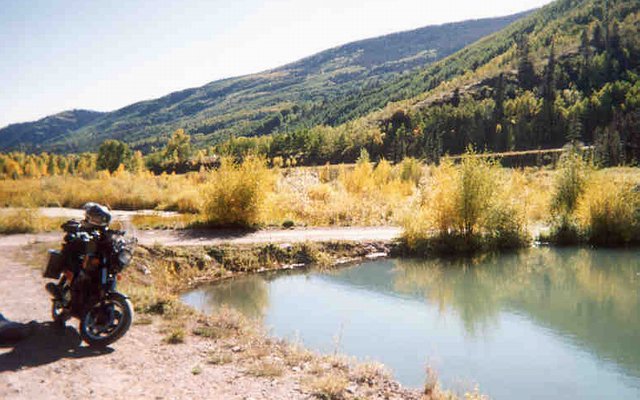
Does the greenish tint of this water look familiar? That's because it's a hot spring! Just north of Rico, elevation 9000', and there's a really nice little tub hidden off to the right behind those shrubs.
Leaving Rico, I was struck by the obvious signs of mining in the hillsides above a series of greenish ponds. Circling back, I tried to ride up the road zig-zagging up the hillside, but was stopped by a gate. Parking, I asked walked over to one horizontal mine shaft, but it was sealed with a grated door that brooked no argument. I would love to have done some Colorado mine shaft exploration, but didn't really feel like doing a whole bunch of walking right next to the highway. Nor did I expect to find any open shafts in such an easily-accessed area.
That's when I realized that these pools were geothermal. Looking around, I spotted the tub nestled in some heavy brush, out of sight from the highway. Ah, that would explain the three motorcycles parked here! After stowing my stuff and dispensing with unnecessary clothing, I walked over to the tub, where four bikers (two couples) were kicking back, with plenty of room for one more. Excellent!
The Harley-riding couple soon split, leaving me and the couple on the (single) Suzuki V-Strom, Dana (the husband) and Sue. Ironically, when I got back to California, I discovered a letter from Dana to my local bike magazine. Small world!
Dana had until recently lived in San Rafael, CA, and we talked bikes. He recommended a couple of bikes I'd already been considering, including the KLR650 that is the current apple in my eye. I really liked this guy, and his wife Sue, who teaches. Both currently live in Durango, in southern CO. After we'd bathed a while, a small gaggle of local teenage girls asked if we were done so they could take over the tub? Being gentleman (and a gentlewoman), we departed.
While we bathed, or maybe just before, another biker rode up, but didn't get in the crowded tub. His name was Ted (damn I wish I'd taken a picture of him and his bike!), and he lived off his motorcycle. His little Honda Ascot 500 was a sight to behold, festooned with a huge pile of stuff, including a small guitar. When the girls split, he and I returned to the tub where he regaled me with stories of Colorado and Arizona.
Ted lived off his bike, spending his days in Telluride, and riding up into the mountains at night. (In winter he did the same trick, but down in Arizona.) He told me that when he came to Telluride 20 years before, it had been a hippie paradise. Now it's a rich ski resort hell, as I was to discover for myself. As Ted put it, when he arrived everyone drove Volkswagen. Then they got Subarus, then Jeep Cherokees, then Land Rovers. Now they're getting Hummers. As you might notice, Ted is both cynical and bitter, but I liked him a lot, and was glad to have met him.
After tubbing, clean and relaxed, he took off for Telluride, with me not far behind. First I had to take a little water bottle shower (to get my head as clean as my body), lose my favorite hat (not part of my original plan!), and leisurely ride towards Telluride with a stop for a photo at Lizard Head Pass.
Arriving in Telluride, I found Ted at the specified outdoor coffee spot. I played his guitar, and took in the resort hell that the gorgeous town of Telluride had become. The buildings were beautiful, as were the women, but the whole resort thing certainly rubbed me the wrong way. I'm told that business jets routinely fly into the town airport (highest commercial airport in the country) for expensive ski junkets. We also rode the gondola up the mountain, down the other side, and up another mountain -- a three-stage gondola, just like in the French Alps, payed for transportation funds to reduce car traffic. And free, quite unlike the one I rode in Europe.
There was still some counter-culture surviving in town, as typified by the "free box", and large section of bins with discarded yuppie stuff. Ted told a story about how, in the late 80's, a contingent of Politburo members from the USSR had been in Telluride for a conference. Walking through town, they were stunned to see the free box, overflowing with stuff that, back in the USSR, you couldn't get even after waiting for hours in line. Ted believes that part of the reason that the Soviet Union fell was because of seeing the free box in Telluride. He might be right.
As night approached, Ted took off for the mountains, after recommending a spot or two for me to camp in myself. He didn't invite me to camp with him, which was probably just as well. He didn't drink, and without drinking beer, where's the fun in camping out with strangers? Following his directions, I headed back towards the pass, and went 5 very rough miles up a dirt road, though the freezing night. I stopped on the way check out a possible site, and browbeat some kids who by the sound of it were fucking with a decaying mining cabin, very uncool. But the spot I ended up in, a totally unimproved and no-fee National Forest campground, was great.
|
|
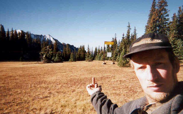
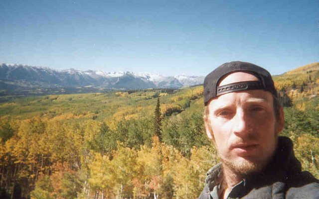
My morning walk above my campsite near Telluride. After climbing the hill above the campground, I was surprised to find ski slopes, a lift, and signs telling you what you're not supposed to do. This photo shows a mountain meadow, with a rope strung across at head level, attached to a gate in the middle. The idea is that, if you want to pass through this area, you'll have to go through the gate, and read the signs which say that if you go beyond this point, you're on your own. I say, "fuck you, cowards and lawyers." Am I being too harsh? Is it wrong to ask people to take responsibility for their own actions, instead of suing someone for millions of dollars because you did something stupid? What's next, signs in every public bathroom saying "Don't forget to wipe"?
As described in the caption above, I went for a splendid little walk in the morning, as usual. Packing up, I zipped back down to Telluride, for the sole purpose of trying to find Ted so I could snap a photo. But it was for naught. Back on the road, I made for the sweet little town of Ridgeway, and then north on Hwy 550.
At this point, I was getting a little pissed off at the crowds in Colorado. In Utah, I could understand it, September must be a great time of year to beat the heat. But way up here in CO? Maybe the fall colors and splendid weather brought out the crowds, I hope so, hate to think it's this crowded all year. Coming into the major town of Montrose, and passing the Walmart, my anger peaked. Fortunately, relief was just minutes away.
Stopping in Montrose for gas and gas station grub (hot dog and a Sprite, if memory serves!), I got happy again. Standing around at the gas station, fueling up, wiping the windshield and faceshield, etc, I enjoyed seeing the working people come and go. These weren't tourists, but painters, and builders, and other wage slaves. An as far as large, semi-squalid American ag/working-class towns go, this one was all right. It was either that, or the hot dog, that put my mind at ease.
|
|
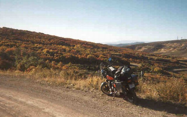
East of Montrose, in the rolling desert hills, a forest of 10' tall shrubs takes on their fall colors.
Hwy 50 east out of Montrose mostly follows the Curecanti National Recreation Area along the canyon of the Gunnison River. It's very pretty to see such a major lake/river going through what is essentially high desert terrain. I almost camped at the east edge of the NRA, but instead pushed on to a punishing after-dark evening in Gunnison and points north.
Gunnison is a hell of a town, one of the very few towns that make me want to actually live there. The presence of a major college is no doubt partially responsible for the hip and thriving downtown, both of which help the town transcend a merely tourist/recreation feel.
While searching the town park/visitor center for water and excellent maps, I ran into Doug from Tucson. He described himself as a "full-timer", meaning he was retired (school teacher?) and now lived in his RV, traveling the country. Sounds good to me! Doug mentioned that the temperature acclimation that one experiences living in Arizona is a two-edged sword. Though 100-degree days may not bother you any more, a 50-degree day can seem really cold. I'll take 50, myself.
Heading north out of Gunnison is when the trouble began. First I stopped to phone Jim in Denver, thankfully (and unexpectedly for both of us) he would be able to put me up the following night. Excellent! But back on the bike, riding through the cold dark mountain night, I just couldn't seem to find a place to hang my hat. After some 20+ miles of freezing wind and mentally kicking myself for not camping back in the nice warm desert near the NRA, I finally found a passable minor dirt road to camp upon. And thanks to a 25-ounce can of beer, I ended up passing out still is my suit. This was the night I discovered that you can wear the suit inside your sleeping bag, but it's not really a good idea.
Okay, maybe this experience doesn't really qualify as "trouble", but it was unpleasant, or so it appeared during the evening. There's something about riding through the freezing night (did I mention that already?) for an hour to find a sub-optimal campsite that makes one feel like an idiot. And when an endless stream of cars drives by in the morning, within line of sight, well...urinidiot.
|
|
The aspens/poplar in fall colors, as seen from the Ohio Pass north of Gunnison. See how the colors are patchy? That's because these trees grow in "colonies", with several or hundreds of trees sharing interlocked roots. Each colony changes color, as a whole, at the same time. In fact, it's been said that one of these colonies is the biggest single organism on the planet. Sorry, fungus colonies!
On the morning of Sept 22nd, I awoke to find myself, yet again, in one of the most beautiful places in the world. Except for the traffic on the main dirt road, this country was spectacular. Walking through the yellow forest, or along a little stream winding through brush and conifers, at the foot of tower semi-arid peaks, was very Colorado.
The much-maligned dirt road mentioned above was actually the back way into the picturesque and famous little town of Crested Butte, aka Crusty Butt. After digging the digs there, I headed south, hanging a lefty at the fishing resort village of Almont, with an eye towards crossing the continental divide via a dirt road over Cottonwood Pass. After stopping at the resort store to replenish my hat supply (back up to four, whew!), I started up towards heaven.
|
|
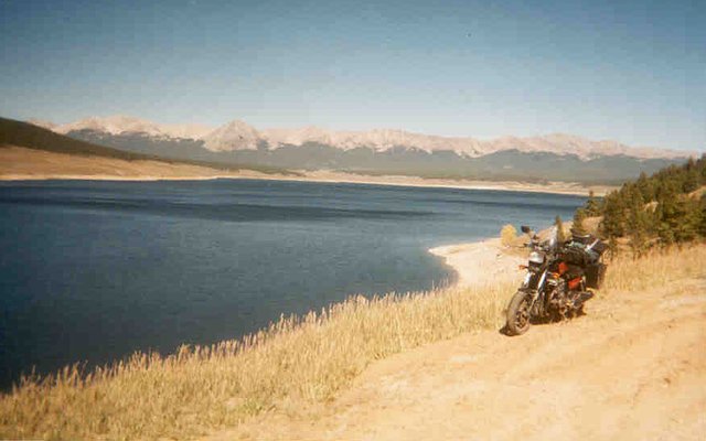
Taylor Park Reservoir, elevation 9000'. Those naked grey mountains are the continental divide, with many "thirteeners" (13,000'-13999' peaks). I crossed this range via a dirt road over the Cottonwood Pass, a low spot off camera to the right.
The road up towards the pass is paved, except for the last 15 miles. And on the other side, the pavement begins immediately, sigh. There was also quite a bit of traffic, I guess I wasn't the only one to want to add this to the ol' resume. But it was very pretty, and historic, this pass having once served the mining town of Tincup. More than a hundred years ago, stage coaches took this same road. The views from the top were of a world far removed from the baser world, isolated by elevation and steep, jagged mountains.
Over the pass, I went into "late-racing" mode. This is what I do when I'm late for an appointment (say, three hours to get to Denver, 120 miles away), and have a reason to ride as fast as I can. Unfortunately, though I've never crashed this way (and not for lack of trying), I may have burned out my engine on this very afternoon.
Once down from the pass, I noticed how quickly I'd descended, but not really put two and two together. The burg of Buena Vista was well named, and somewhat idyllic, except for the (probably poisonous) large state prison south of town. Heading east on Hwy 24, I hung a left onto Hwy 285, which would take me all the way to Denver. The country here was flat and open, a massive valley between the mountains, or so I thought.
Trying to make some time in the wide open country, I ran as fast as I could, but couldn't seem to break 85MPH. Once upon a time, this bike would do 115, and more recently I'd made 105. But I was wearing a small windshield, and I figured, maybe there's a headwind? God knows the wind was both loud and unpleasant enough. And I was quite busy looking out for The Fuzz.
Then I rolled into the quaint and somewhat austere county seat of Fairplay, where the sign at the edge of town notified me that we were at elevation 10,000'. Holy shit! The whole "valley" I'd spent the last half hour struggling through, with the throttle pegged, was actually a high mountain plateau, not between mountain ranges at all. (Guess that explains the snow fences along the basically flat highway.) No wonder I couldn't get my speed up, at that altitude the air is too thin to get anything approaching maximum power. The next day, my engine would start to bellow clouds of oily white smoke, probably as a result of "racing" at 10,000-fucking-feet. Oops!
|

|
My friend James, and his son Henry, what live in Denver. This excellent pic is actually nearly three years old, but so far James hasn't sent me anything more recent. He's a prince among men as a host, but not so wonderful in answering my e-mails. (Can you tell that this photo is a little dated?)
The last hour or two of my march on Denver was something of a blur, both figuratively and literally. Normally I stop constantly and smell roses, but when late-racing, not so much. As night fell, and I encountered the rush hour traffic of a major city, the difference in feel from my last 10 days in the desert and mountains was a bit of a shock. But as major cities go, Denver is pretty cool.
Once I arrived at James and Sara's house, they made me feel right at home. After washing up, James and I sat around in the kitchen, chewing the fat, until he made an early exit for bed. I stayed up into the wee hours, doing laundry, surfin' the net (e-mails and weather), and just plain taking care of business. In the morning, we men (including Henry, what a great kid) chewed breakfast fat around the kitchen table again, then James and I went out to a really nice Mexican breakfast of Huevos Rancheros, before he split for work. I was on my own again.
|
|
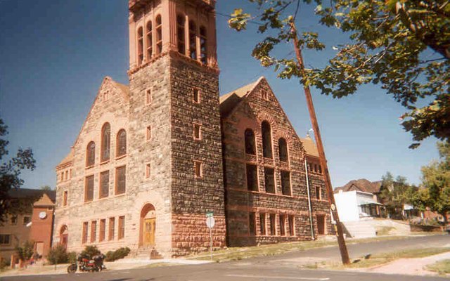
An church in an old Denver neighborhood at the north end of town. I spent a few hours cruising around to get a feel for the city, and the feeling I got was just plain good. Except for the part where my bike's exhaust started spewing oily white smoke, indicating major engine problems!
After breakfast, I cruised Denver for about half the day. There's a big lovely park downtown, and some pretty major state capitol buildings that felt a little like Paris. I could give a blow-by-blow account of what I saw and did, but instead here are a couple of observations.
The residential neighborhoods near downtown were oddly modest houses and small apartment buildings, meticulously maintained. The city itself seemed to stretch on forever, kind of like a desert town, which of course it is. The schools looked well kept, the students not under siege. The homeless and street people were a cut above SF's.
After Denver, I cruised through Boulder, but wasn't really able to find anything memorable, other than the impressive-looking university. Is there any there, there? Probably, but I didn't see it. Starting up into the mountains, I stopped at the market in Lyons for groceries and a sandwich, I really liked the town. Estes Park, not so much, that town seems more trampled underfoot by the Rocky Mountain National Park tourists.
I hadn't really wanted to go through the National Park, because such places tend to feel claustrophobic. But it seemed like an opportunity to see some more high-elevation Rockies. As it turned out, it was crowded (tourists clogging the roads), restricted (very few trail heads and trails), and unnatural -- unlike many mountain routes, which saw horse-drawn carriages serving remote mines, this road was built just for the park, and doesn't really go anywhere. The whole park is a kind of giant tourist loop.
On the bright side, there were rutting elk, and stunning views. The bull elk have an improbable, high-pitched call, which attracts females and tourists. (Hey, I could use that...) In the park, the elk were fearless, which must be quite a contrast with surrounding areas where it was elk season, and there were a lot of hunters about. Personally, as of this writing, I prefer hunters to tourists. I should also mention that I was suffering a little altitude sickness, which may have harshed my mellow just a bit. Eating, taking a little walk, napping briefly against some rocks, and putting on all my clothes all helped to get me back on track.
|
|
I took a walk from the road's summit at Trail Ridge, elevation 12,183'. Note that this is a "summit", not a "pass", because this road pretty much goes over the top of a mountain, rather than seeking the easiest route between peaks. As you can see, the terrain is fairly flat, windswept, and tundra-like, with nothing but rocks and small grasses. An interpretive plaque mentioned that the wind usually keeps this mountaintop snow-free. Also interesting was an observation that the wind is much diminished right at ground level, but becomes stronger a few inches or feet above ground.
With sunset almost upon me, I raced down the west side of the mountain, trying to use the remaining light for some high-speed shenanigans. Here in the park's hinterlands, just before dark, there was much less traffic. Near the park's west gate, there were a bunch of cars, but most were stopped to listen to the amazing elk songs. I stopped too.
As so often happened in Colorado, I was disappointed with the lack of dirt roads for camping. After a few false starts, and a stop at a lakeside resort store for my nightly can 'o brewski, I went through the town of Granby. At was after dark now, and very cold, but I was impressed with the town, which seemed more geared towards "sportsmen" (hunters and fishermen) than tourists. I remember a huge lot with countless snowmobiles lined up, waiting for winter.
A few miles west of Granby I turned north onto hwy 125, which goes 55 miles through the mountains (and high desert at the north end) to the town of Walden. But I only went about 9 miles, just past the border of the Routt National Forest, then turned off onto a gravel road. Just a mile or two from the pavement I found an excellent little streamside camping area, right next to the road but otherwise a dream. After setting up camp, I took a walk to get warm, and was unhappy to discover a light just a 1/4 mile further up the road. I later discovered this was a trailer, parked next to some construction equipment. Road work?
The next morning, it was cold as hell. Although the day was beautiful and clear, my campsite was in a deep valley. Apparently, just as hot air rises, cold air sinks, and my thermometer refused to break 20 degrees, even at 10:00AM when I departed. On the way back to the highway, I stopped at an amazing rustic cabin, still in use and complete with corral. I was pleased to see the cabin in such good condition, it being just half a mile from the highway, and only 100' from the gravel road.
Heading north towards Walden. I was impressed with how quiet and undeveloped this area was. After perhaps 20 miles the National Forest ended, and the country flattened out, becoming high desert farming/ranch land. I took a 6-mile "nature drive" through the desert, past a couple of small lakes, and finally accomplished one of my more minor life-long goals: Seeing prairie dogs. They're cute.
The town of Walden was somewhat earthy, perhaps a little down-and-out, and seemed too small to be the county seat. Which was sort of nice, after my tourist shock in most of Colorado. This area was called (I think) "north park", a "park" being a major valley surrounded by mountains. The market downtown was out of business, always a danger sign. When I mentioned that I was concerned about the town to woman at one of the gas stations, she said that the owner "didn't want to work", and that there was another larger market outside town. When I asked if the town could support two markets, she said "yes", rather rudely. A bit cranky, I thought. My stop at the auto parts store was much more pleasant.
Heading north-west, I stopped on a dirt road to eat an apple near the North Platte River, by some granite outcroppings that could have been in a prettier part of western Nevada. Minutes later and back on the highway, I crossed the state line into Wyoming.
|
[
previous |
next
]
[
Reno |
Nevada |
Utah |
Colorado |
Wyoming/South Idaho/Montana |
Idaho |
Oregon/California
]
|


