|
[
Reno |
Nevada |
Utah |
Colorado |
Wyoming/South Idaho/Montana |
Idaho |
Oregon/California
]
UTAH
|
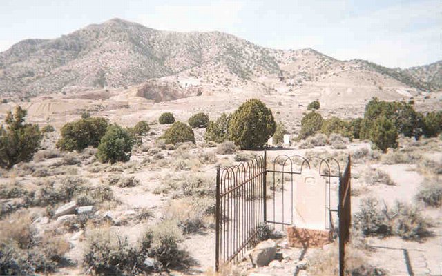
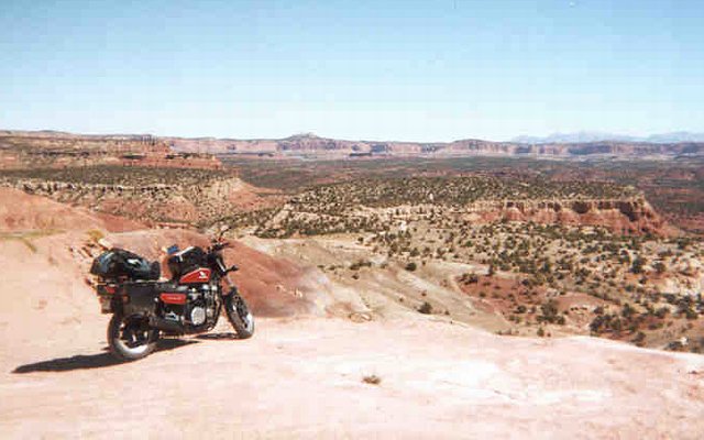
The cemetery at the ghost town of Frisco. Interestingly, most of the gravestones are for infants. Not really shown is the fact that most of the graves are marked by simple circles of rock in the dirt. In the distance, you can barely make out the remains of one of the most productive mines in the West, circa 1885-1900.
Entering Utah from Baker, Nevada, as darkness fell, I tried to make some time through the darkness. Unfortunately, I hadn't yet realized that pushing on through the dark generally saves no time at all, because you'll spend much longer finding a campsite by headlight. (More than two weeks later, I still hadn't realized this. Maybe next trip?!?) On the other hand, it can be pretty damn cool dirt roadin' through the dark, helmet off, twelve feet tall on wings of fire.
After a false start or two (one up an excellent but too-short road from the hwy 21 summit, another ending at a rancher's fence and windmill/water tower), I found a bodacious little dirt road. As I mentioned above, dirt-roadin' at night is really pretty cool. But finding a good spot to camp can be a challenge. You want beauty, isolation, shelter from the wind, good morning sun protection, a flat spot to sleep, a nice place to sit up before bed, etc. Like a dog circling before laying down, this can take time. And rarely will you achieve all of your objectives. Normally, what you want is to follow a paved road, then a good dirt road, then some little spur road that peters out into a track or dies altogether. This way, the chances of someone driving by in the morning are almost zero.
The next day, I took the obligatory morning walk. Although I hadn't realized it the night before, I was now in cactus country. Welcome to Utah! There were several other horticultural delights growing on this hillside. The differences between Nevada and Utah are really pretty significant, even here on the boring western border of the state.
Hitting the road, my first stop was the ghost town of Frisco, at the foot of Frisco Peak. The picture above shows the view from the cemetery, not that far from the highway. This ghost town is private property, but I didn't let that slow me down. Finding a route around the rather impressive ditch that once sheltered the town from tourists like me, I proceeded to spend a couple of hours walking and riding. There were quite a few structures still standing or partially standing, and some major mining facilities. There were also a few charcoal kilns, treasured artifacts of the mining past, protected by a fence.
Back on the highway, I talked to a woman from Marin County, who was taking a solo trip of the West. A rather large woman in tai-dye and an art car, she stood out in Utah like a sore thumb. She told me about the wild art community back in Baker, NV, and it sounded like she was having a wonderful trip.
|

|
This abandoned mine isn't that old, but it's still very cool. Appropriately, it's just west of the very cool town of Milford.
On the road again, I made for the town of Milford. But first, a stop at a fairly recent, but still abandoned, mine. In town, I stopped at the supermarket for provisions. Walking the market aisles, two different people said hello and asked how I was doing. When I allowed as how I was doing fine, except for the wind, one older gentleman said, "It's always windy here." And I'll bet it is. Next I dropped by the local sports complex to refill my water bottles, and then the downtown gas station for a spot of petrol. While filling up, I talked to an older couple (he on a Gold Wing, she on a Honda cruiser of some sort). Like many people I'd met this trip, the man was familiar with the Bay Area. Having come down from Salt Lake City, he mentioned something about the wind ruining a perfectly good day's ride. He probably was feeling a little guilty for subjecting his wife to these harsh conditions.
South of Milford is the smaller town of Minersville, which was charming (like most places in Utah that I encountered), but not quite as "real" as Milford. As usual, I spent a while riding through town, both on the main drag and through the residential areas.
Next stop, the county seat of Beaver, a rather large town is on Interstate 15. I didn't spot the Wal-Mart, but there were Wal-Mart trucks around. (Someday, when there are only a few different chain stores left, there will be only a few different kinds of trucks on the road.) Heading south out of Beaver, I did 15 miles on the interstate, the only interstate time since Reno, and until Denver. These roads are to be avoided whenever possible, unless you really need to make time, and/or don't want to see the country you're passing through. Departing I-15, I took hwy 20 over an amazing little stretch of semi-arid mountains and plateau, made more difficult by some major road work in progress.
Then down to hwy 89 (a road later recommended to me by Leroy in Idaho as a great north/south route) and the town of Panguitch. This beautiful town, and county seat, has been somewhat "boomed" due to it's proximity to Bryce Canyon and the Escalante region. After gassing up at a mini-mart staffed by some really sweet teenagers, I passed through the almost unspeakably beautiful Red Canyon, just missing an opportunity to take a picture in the red light of sunset.
Coming out of the canyon, the land (just west of Bryce) became flat and wide National Forest, with plentiful dirt roads for my camping pleasure. Heading north maybe ten miles, I nearly dropped the bike during an impossible and just plain stupid little hillclimb attempt, barely managing to turn around on the steep narrow "road". But the angels were on my side, and they proceeded to lead me up another, much better two-track road to a lovely little campsite at road's end and night's beginning. Interestingly, this would turn out to be my only real travel day where I made camp before it was completely dark.
|
|
Highway 12, which goes by Bryce Canyon and through the much larger Grand Staircase-Escalante National Monument, is simply the most beautiful road in the world. At least, that I've seen. And the thing about southern Utah is, every hour, you discover an entirely new kind of beautiful. I guess that's why they call it the "Holy Shit!" state.
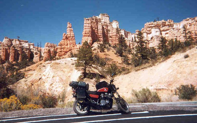
In the morning, after a walk, back to the highway. I started for Bryce Canyon, which is a cul-de-sac south of Hwy 12, but turned back at the entrance after learning it was $10 to get in. (Later the next day, three bikers described Bryce as "road work, traffic, and mud", so I guess I made the right choice!) After a little dirt road play in the beautiful forested country near the park entrance, I continued east, stopping for the photo above, which probably gives a taste of Bryce.
I went to ground at the ranger station in Cannonville, an excellent combined BLM/NPS facility with lovely bathrooms for washing and other needs, a spigot for refilling water bottles, and a visitor center. There's also a great little town park, the perfect spot for lunch in the shade. Mounting up, I started for Kodachrome Basin State Park, but turned around after a discouraging hand-gesture from a passing biker's passenger. Must be a bad road, and I needed to make some time anyway. Leaving Cannonville, there is a simply amazing section of the road where it goes up and through an opening in a cliff face. Like I said above, the most beautiful road in the world, as far as I know.
Pushing ever onwards, I tried to make some good time, but Hwy 12 is no place for hurrying. The views were beyond belief, almost painfully beautiful. I stopped for an illicit walk along a soft sandy promontory -- it became apparent why it was fenced off, the ground was very fragile. Back on the highway, I decided that maybe it was time for a little long-overdue bathing. Riding up a major gravel road for maybe five miles, I found a deep spot in the creek just big enough for full body immersion, which I followed with a nice water bottle shower. The back to the pavement, later than ever. (For what?!?)
|
|
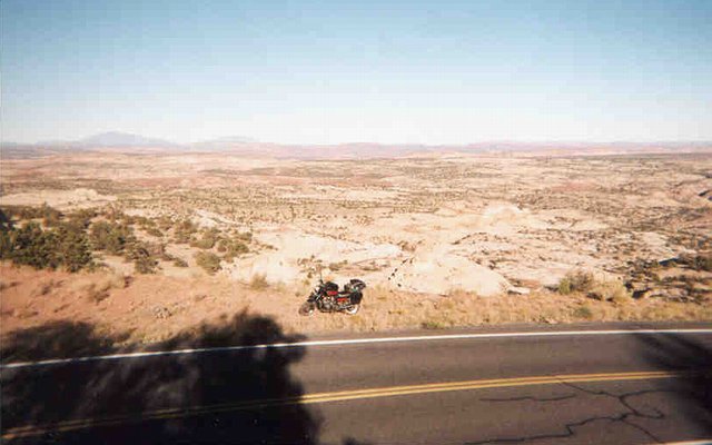
Well, this picture from Hwy 12, just east of Escalante, doesn't really say very much. So you'll have to take my word for it -- it was bitchin' beyond words.
The town of Escalante has an Old West kind of feel, though nowadays the town runs on tourism. East of town, the road crosses the Escalante River, which has a trail running alongside, in a deep canyon. I walked this trail for a mile or so, quite a setting: Willow and other desert riverside trees and brush hugging the banks, with steep red sandstone walls towering above. Highly recommended.
I guess this would be a good time to talk a little about the Grand Staircase-Escalante National Monument. In the late 90's, as just a part of what is universally known as the Clinton Land Grab, this huge section of unspeakably beautiful desert was transferred from the BLM to NPS (National Park Service) and given "monument" status. The result is closed roads, signs telling you what you can't do, the end of commercial use, etc. And I'm pissed, as usual when my rights are taken away by the government. And you can bet the locals, many of whom have been using this land since the settlers arrived more than a hundred years ago, are even more angry. (One shopkeeper told me about a county commissioner who followed the NPS trucks around, pulling up the newly placed signs.) But in the government's defense, I should mention that this area is so beautiful, and so popular, that the Monument status is really no surprise.
As Hwy 12 leaves the Monument, the road travels along a ridge known as "The Devil's Backbone" to the little town of Boulder. This village (a store/gas station or two, restaurant, school, post office, and Mormon church) is said to be the last town in the U.S. to receive regular year-round mail service. Prior to the 1930's, winter snows would block the route from the north, and to the south no good road existed before the amazing ridgetop road. Now, things are different, with an endless series of cars touring this most extraordinary route.
I stopped in Boulder for gas and gas station grub. It was after dark and getting cold fast, and my job was to find a place to sleep. At the gas station, there was a van full of young Czechs, who were behind schedule and trying to figure out how to complete their grand tour of the western U.S. They were wondering whether they should drive through the night to reach Bryce. I told them they'd miss seeing one of the most beautiful roads in the world. Poor lucky bastards, they had an embarrassment of riches, with too much to see and too little time. Their plan called for Bryce, Zion, Death Valley, Kings Canyon/Sequoia, and Yosemite. For myself, I had to decide between staying on Hwy 12 to Hwy 24, or ditching the traffic and pavement for a "shortcut" through the Monument, along the Burr Trail. Can you guess which I chose?
Heading down the Burr Trail well after dark, I went about 10 miles on the pavement, then got off onto some small and very soft red dirt roads. After nearly getting stuck, riding around in the freezing cold with my helmet off, I found a nice spot and settled in for the night. (Only the next morning did I see the "No Motorized Vehicles" sign at the start of the road, which I would probably have ignored anyway. Federal bastards.)
|

|
The nice thing about making camp at night, is waking up to discover just how amazingly beautiful the spot you found really is.
Waking up on the morning of Sept 18th (a.k.a. Day 8) was a shock. I thought I was camped along some dusty red dirt road, that strangely ended much too soon. As it turned out, I was near a cliff at the edge of a canyon, in a red dirt wonderland. A pleasant surprise, just one of many this trip.
|
|
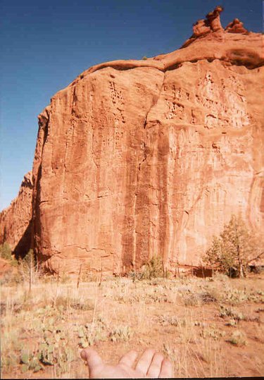
The view from the bottom of the canyon pictured above, with a natural cactus garden in the foreground, and a primitive cattle fence behind.
|
For my morning walk I found a way, with some difficulty, down to the floor of the canyon. This area, despite its amazing beauty and small size, had been used for cattle grazing, and there were a few fences. I don't know if the Monument shut down the grazing or not. This canyon leads west (or more likely, comes from the west) to Boulder, some 8 miles away, and was probably the easternmost extent of some old cattle ranch
When I returned to camp, packed up, and got rolling, I was surprised to see another vehicle coming down the dirt road. Usually, when I camp at the end of a dirt road like this, I see no one, certainly not close enough for talking. But three mornings before, I had had a similar experience. This was just a little disturbing, because part of my practice and philosophy of dirt road camping is that ideally you choose a place remote enough that you have it all to yourself. Just bad luck, I guess. And of course, often I camp alongside a road, instead of at the end of one, and in that case it's not unusual to see people driving by.
Back on the pavement, the Burr Trial went through a stunning red rock canyon, where I stopped to chat with three bikers on Japanese cruisers (not Harleys, Hondas). These guys had started from New Jersey, done the famous Route 66 out to L.A., and were now heading back to Jersey. They were in the process of giving up on the Burr Trail, being uncomfortable with the probability that the road would turn to dirt and gravel. As it turned out, their fears were justified. Although the road was mostly paved (despite the map's claim to the contrary, must have been gravel until fairly recently, damn Feds), the last bit was gravel and dirt in the worst way, with miles of hated washboarding trying to shake the bike to pieces. I wish I could have told them that they made the right decision. As did I, with my abnormally high tolerance and fondness for bad roads.
|
|
This is where the Burr Trail opens up into amazing and vast canyonlands. As usual with these photos, this picture doesn't even begin to do the scene justice. Also, this is the last photo from my first roll of film, the next roll doesn't begin until Colorado. Hence the volume of text below!
The Burr Trail through the Monument was fantastic. Though the road was paved, and tourist traffic fairly heavy, there were also a goodly number of red dirt roads through red dirt desert. (I hope the road network is more extensive, and connects with the outside world more, than the maps I saw indicated. Gotta get a book of Utah maps!)
As the Burr Trail climbed out of the valley shown above, and entered the southern reaches of Capitol Reef National Park, the road became gravel. After stopping for a sandstone picnic, I headed south towards Bullfrog Marina and Lake Powell. The road here turned to badly washboarded gravel, very unpleasant. But once the pavement returned, and in fact even before that, the route was incomparable. The final few miles before Hwy 276 snaked along the top of a red dirt ridge line, wow. Wish I could have stopped to enjoy it, but I was burning rubber in hopes of catching the Bullfrog ferry before it quit for the night.
Down at Bullfrog, there's a tollbooth for entering the Glen Canyon Recreation Area. The old guy in the booth let me in for free, but he gave me some incorrect info about when the next ferry departed. He said 7:00, but in fact the last run had been at 5:00. I stopped at the visitor center for water and civilization, then at a gas station for supplies. Going down to the ferry "dock" along the sandy shore, I swam, drank a beer, and waited for the ferry not to come. Which was fine -- what could be better than swimming for half an hour in a vast freshwater desert lake (dammed river) after a week of camping? Afterwards, relatively clean and refreshed, I headed north in search of a campsite. But before leaving the dock area, I almost dropped the bike at 15MPH in the loose dirt of the parking lot. (Must have been a pothole, filled with dirt?) That would have been a horrible surprise, and I'm still frightened about what could have so unexpectedly happened. A real ankle-breaking opportunity, narrowly missed.
Heading north on Hwy 276 in search a little patch of desert to call my own for the night, I kept my eyes open for a good lateral dirt road. For more than 40 miles! There was a road or two, but it was dark, which makes it very difficult to spot smaller side roads. And then things got interesting, when my headlight failed. Thankfully the road was straight, and there was little traffic.
First I tried cruising along with just my running lights and a flashing blinker for light. This worked surprisingly well, but didn't reveal any side roads. I think I made it 5 or 10 miles this way, to the junction with Hwy 95. Turning around to go back down Hwy 276, with its relatively light traffic, I tried riding with my 2-AA-cell maglite flashlight in my right hand. This also worked surprisingly well, in a pinch. But every time a car came from the other direction, I pulled off and waited for them to pass. I didn't want any help, or cops, getting involved -- all I needed was a place to sleep, and I'd figure out the rest in the morning.
Weary of pulling off every minute, I decided to try yet another headlight-less tactic. When a slow vehicle (pickup pulling a trailer) passed in my direction, I put the pedal to the metal and took up position right behind him. This worked great, the light from his headlights being more than adequate to allow me to maintain 60MPH.
Finally making it back to a major dirt road heading west, the one I should have stopped at when I first passed it (the story of my life!), I pulled off. Unfortunately, this road was treacherous with occasional deep sand, so I needed better light to continue safely. Wedging my flashlight under the windshield, I was back in business, and two miles later found a happy home next to a couple of gravel piles used by the local highway department. Piles like these are common in the desert, for highway maintenance I guess, but this was the first time I ever slept next to one.
In the morning I went to work on the headlight. Pulling the bulb revealed no problem there, which was no surprise, because headlight bulbs have two filaments (low beam and high beam), so you normally always have a fallback after a failure. I used a paperclip and a twisty tie as wiring to send power to the bulb directly from my battery, which showed the bulb to be fine. Checking the fuse box revealed a burned out 15A fuse, which I replaced with a spare 20A. Maybe the fuse blew because, when toggling between low beam and brights, both filaments are briefly on. This "spike" must have burnt the fuse. At any rate, problem solved. Over-achieving primates one, electrical gremlins zero!
Back on the Hwy 276, then 95, overwhelming beauty again reared its beautiful head(s). A dozen photos wouldn't do this area justice, but I took zero until reaching Colorado. Despite my constant irritation this day with government regs restricting one's activities in some of these areas, I was a happy camper. (When walking near the bridge across the Colorado River, I found a pile of bottles, bedsprings, and other trash, and was happy to see it. Isn't rusty old garbage part of what the desert's all about?) Getting low on gas, I found that the "town" of Fry Canyon, which looked almost prominent on the map, was actually just a motel with a single gas pump. Intelligently, the motel office was only open after 4:00, when guests might start to arrive. But fortunately someone answered when I rang the doorbell, allowing me to buy some gas, otherwise it might have been an interesting afternoon when I ran out along the road.
(I wonder what Edward Abbey, author of The Monkey Wrench Gang, would think about the whole Clinton Land Grab? Would he support the additional protection afforded the land, or chafe under the governemnt restrictions? For myself, in my current frame of mind, I'd prefer a nice, well-aged pile of garbage to just about anything involving a National Park Service sign.)
|

|
Somewhere around here, I stopped at a park, almost hidden just off the road. Taking a 1/2 mile walk, the "interpretive trail" ended at some amazing indian ruins, built into a series of large caves. Extremely cool! But, the picture above is of the much larger ruins at Mesa Verde National Park, which I've never seen.
Eventually I made it to Blanding, yet another nice civilized little Utah town, near the foot of the Abajo Mountains. There was a smallish jail at the south end of town, and quite a few Indians living in the neighborhoods. (Just across the border in Colorado, someone described the area as tri-ethnic: White, American Indian, and "Mexican".) My map shows that near here is the Ute Indian Reservation, from which tribe the state of Utah gets its name.
I pushed on north to the cozy and real county seat of Monticello. At the supermarket, I happily resupplied (including a new camera!), and remember well that much of the staff was Mexican or American Indian, including the cologned and slightly rude camo-wearing restockers. There was also an elderly Indian (as in, from the sub-continent) couple in line in front of me, which seemed a little surprising. Trivial details aside, I stopped on the edge of town at the local Honda dealer, looking for a replacement gas tank filler cap seal to stop the bad smell I'd been experiencing. Though it turns out this part isn't sold by Honda, two Goldwing-riding patrons (possibly from Salt Lake City) suggested an alternate solution, that I "drive a new bike under that old gas cap". While slightly rude, it was quite funny, and allowed me an opportunity to mention that this bike had a certain sentimental value, developed over 50,000 miles of riding. I'll bet that got their attention! At any rate, events would prove that they were probably right, read on for the whole story.
|
[
previous |
next
]
[
Reno |
Nevada |
Utah |
Colorado |
Wyoming/South Idaho/Montana |
Idaho |
Oregon/California
]
|


