|
[
Reno |
Nevada |
Utah |
Colorado |
Wyoming/South Idaho/Montana |
Idaho |
Oregon/California
]
NEVADA
|
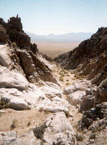
A really nice and somewhat rare (for western Nevada) slickrock canyon, east of Fallon.
On Sunday evening, after two nights and two days of beer-drinking (and I use the word beer loosely) and plane-watching, I left the Air Races and hit the road. Ross rode with me back to Reno through the heavy traffic, and I filled my water bottles at his sister's house. Then, off into the night and solitary adventure.
I'm not very fond of night travel, because you don't get to see what's around you. But I had been this way (hwy 50 between Reno and Fallon) a couple of times before. In fact, I knew just where I was going. Fallon, in the middle of western Nevada, is a major Navy airbase, with four bombing ranges approx 30 miles away. One of these is just south of hwy 50, and I camped right near by. (3.6 miles south of hwy 50 on hwy 839, leave the pavement at the cairn and head for the canyon.)
This turned out to be an excellent campsite. In the morning I walked for an hour or two up a beautiful canyon. There, I found slickrock and a colony of the biggest black/yellow wasplike insects I've ever seen. Walking in the morning like this is standard procedure for me, and part of the reason I rarely travel more than 250 miles/day. Even when bike touring, every day should include a couple of hours of walking, if possible.
|

|
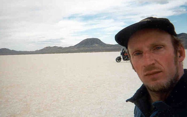
The photo really doesn't do this view justice. Eight Mile Flat, which is crossed by hwy 50, is an amazing bright white salt flat, seen here from well above and to the south.
Instead of heading for Colorado, I went dirt roading first. There's some kind of Department of Energy (read: nuclear) facility right around here, so I was curious. I didn't find the facility, but I did find a surprisingly wide gravel road, which means there's either a large operating mine or some other kind of facility nearby. (There's a similar road that leads to the legendary Area 51, large and unmarked.)
|

|
One of the many, many corrals that are everywhere inthe Nevada desert. This one is probably still used for cattle, one of the few sources of income from the desert. And cattle are good people.
At the foot of that mountain is the bombing range. This amazing facility, probably 50 square miles in size, contains many dozens of fake buildings, and nearly as many vehicles, for aircraft target practice. And the range is clearly visible from the road. This time I didn't see any planes, but there were a half-dozen old M-60 tanks parked near one of the gates, no doubt waiting to be positioned on the range. And out on hwy 50, I saw a truck driving with a large and obviously fake missile on the back. Training jet pilots to recognize SCUD launchers doesn't require finely detailed mockups.
In the past, I've seen some amazing displays of airmanship. One time, a couple of F/A-18s, escorted by a F-14, came screaming overhead at treetop level in a turn. The F-14 peeled off, and the F/A-18s dropped practice bombs (poof! bam!) then soared up into the clouds, jinking wildly and dropping flares/chaff. Pretty damn impressive.
|
|
A dry lake off of hwy 722. Either this is one of those extremely rare "slanted" dry lakes, or I scanned the picture crooked and was too lazy to fix it. Not sure which.
Heading east on hwy 50, I took a detour to get away from the fairly heavy traffic to be found on the so-called "loneliest road in America". Hwy 722 goes over (instead of around) the lovely Desatoya Mountains, then through flat desert complete with a dry lake, then lastly past the ranch/farm country of the Reese River valley south-west of Austin. I rode around on the local airstrip, as is my want. Most desert strips have no fence, just a sign telling you not to ride around on the runway. So I did.
|
|
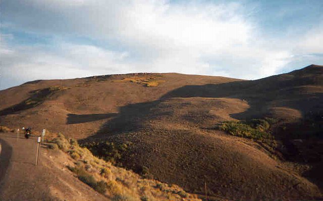
The soft golden hills above Austin. Those patches of color in the distance are groves of aspen trees. Austin is a really striking town, halfway up a mountain pass (towns are almost always in valleys, where applicable) and carved into the hillside. Old buildings and tailings piles everywhere make for an unforgetable sight.
I resupplied in Austin, a tiny little town halfway up a mountain. Though they only have two mini-marts, there is an excellent little town park with bathrooms and water. Then up and over the summit, through the juniper forest, and by the time I reached Eureka it was dark. Eureka is a county seat, but it's still quite small with a beautiful historic district. In fact, all I saw was the historic district. If there's a Safeway or a Walmart (and I hope there isn't), I didn't spot them.
I parked in Eureka for a little nightime stroll. Chancing upon a sheriff making his rounds, I walked with him and struck up a conversation which ended up lasting nearly two hours. His name was Ralph, and he was full of interesting opinions. I (tactfully) asked if he felt any guilt about doing his job, and he said no, none at all. He came off as an amoral law-enforcing machine, perfectly suited to being a cop. When I commented that his reponses were similar to those of a psychopath (no remorse), he said yes, but there's a difference. Don't get me wrong, I really liked the guy, and he was very intelligent and dedicated. He described his primary job as mitigating conflict. We discussed politics, books, his military service as a medic in the Philipines, farm upbringing in Indiana, everything. And before I left, he basically called me a fool for travelling anywhere without a loaded gun in my vehicle (legal in Nevada). I'm really glad to have met him.
|
|
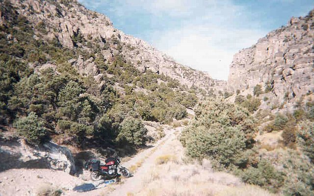
A fairly typical Nevada campsite, near the end of a dirt road climing into the hills, in this case 20 miles east of Eureka. The road itself is often the best campsite.
After leaving Eureka, I rode for nearly an hour looking for a good campsite. Finding a site at night is much harder than in daylight, but nonetheless I did it ALMOST EVERY SINGLE NIGHT for three weeks. The good thing about riding through the night, looking for a site and mentally beating yourself up about it, is when you wake up the next morning and discover that you are in an amazing and excellent place. But's it not easy, when all you can see is the silhouette of the mountains, with no idea of how far away they are.
On the way to this campsite, I nearly crashed twice. The first time, just outside Eureka, a group of deer crossed my path. I braked like hell and came to a stop just past (and inside) the group. Would have been a low-speed encounter. The second time, a rabbit ran across the road, and again I braked too hard. In the first case, I was travelling too fast for my sight distance. In the second case, I should have braked moderately and let the rabbit take his chances. And having just crashed three months before from a front brake lockup, I was suitably spooked and ready for camp. Unfortunately, a really good site was not easy to find. Compunding the problem was a major powerline project under construction.
In the morning, I took the usual walk and discovered a not-that-old abandoned mine, and some substantial stone foundation/walls, up the canyon. Unfortunately I made the rooky mistake of not bringing a flashlight, so I could only get about 200' along the mineshaft. Looked like a pretty long one, too. When I got back to camp and packed up, a pickup drove up. This is unusual, to have another vehicle drive up to one of my campsites. But he was a nice guy, a schoolteacher who grew up in Ely, and he left his truck (with a lot of stuff in the bed) and jogged up to the old mine. I left shortly afterwards, riding past his truck and down to the highway, then back again to find a glove I had dropped. Hence my name for this spot: Dropped Glove Canyon.
Next stop, the major town of Ely (pronounced "elly"). This county seat is a pretty large town, though I still didn't spot the Walmart, as far as I can recall. The old downtown is in good shape, and I spent the afternoon there, eating store-bought lunch in the park in front of the courthouse and library. The aformentioned store, one of many medium-sized markets that I stopped at, was a wonderful example of the kind of business you don't see much anymore in the Bay Area. A full line of groceries and vegetables, bakery, and deli, served up by folks not wearing corporate outfits. The woman at the deli counter made the soup herself, it was really cheap (with a sandwich), and when the line at the checkout counters got too long, she came up and helped out there. Very cool, and one of the highpoints of the trip.
Then onward and eastward, around the huge mountain range that defines Great Basin National Park (looked interesting, but claustrophobic like most national parks). Stopping in the tiny hamlet of Baker, I managed to buy a "four-pack" of beer at the store, cheaper than a six-pack but not much more expensive than a $2 single. The nice folks there also filled my water bottles and kept me from parking on the newly tarred and still wet roadside.
Ten minutes later, I was flying through the encroaching Utah darkness, with a tank full of gas and a pack full of beer. Life was good!
|
[
previous |
next
]
[
Reno |
Nevada |
Utah |
Colorado |
Wyoming/South Idaho/Montana |
Idaho |
Oregon/California
]
|


