|
[
Reno |
Nevada |
Utah |
Colorado |
Wyoming/South Idaho/Montana |
Idaho |
Oregon/California
]
WYOMING/SOUTH IDAHO/MONTANA

|
My first (and only) night in Wyoming I camped in the desert, just north of the Great Divide Basin. This is a kind of minature Great Basin defined by the mountains of the Continental Divide, which splits into two for about 100 miles. As you can see, it's classic western sagebrush desert, distinguished somewhat by the shape of the hills in the background, with clearly visible tabletop plateaus. There were cattle grazing nearby, a fact which the really discerning viewer might have surmised from the cropped look of the sagebrush.
I entered Wyoming from Colorado, on hwy 230. It was Thursday, September 25th, 2003, and I was running late for my goal of reaching northern Idaho by Sunday afternoon. Because of this, I only spent one night in Wyoming, despite crossing a large part of the state. Now I want to go back and see the rest! Likewise with Montana, and the Black Hills of South Dakota, and...
My first stop was the town of Encampment, which blew me away. Actually, the wind really did try to blow me away, and was a constant problem until I reached the mountains near Yellowstone and Grand Teton National Parks. Earlier in the trip, two different people had told me stories about the Wyoming wind, and the "arctic" conditions I should expect in late September. Well, the tempatures were just fine, thank you very much, but the wind was a serious nuisance. Back in Nevada, Ralph the Sheriff had told of being simply unable to open a car door facing into the wind, and someone else had talked about driving their kids the two blocks to the bus stop. Now, I believe it!
Anyhow, Encampment was awesome. There's an incredible little town park, with about a dozen old buildings that have been moved to the spot from around the region. Although a bit disjointed, walking amongst these buildings is the closest I've ever come to being in a frontier town. The rest of the town (what there is of it) is also really cool. There's a tiny restaraunt, and a little "package store" where I had to wait around for a few minutes for the clerk to come from the back. And there's an old-style gas station/store outside of the downtown, where a local old-timer told me that the weather was always like this in September. Warm and windy.
While having lunch at the town park, I thought about a possible "shortcut", heading east on hwy 70, then north about 50 miles on a mostly-gravel road. A roadside historical marker had mentioned the prescence of old abandoned mines, something conspicuously absent from this trip so far. I stopped at the ranger station in town to ask about the route, and got a little info and a really nice tourist map of the state. The ranger woman was really nice, both to me and to two young hunters that came in, asking about where they might better find game. They really smelled bad. Was it just lack of showers, and did I smell just as bad? Or had they been drinking all day while waiting for game, and it was the alcohol I smelled? I suspect the latter.
I decided to skip the "shortcut", and may never know how cool it was or wasn't. Continuing north, I briefly cruised the nice little river tourist town of Saratoga, then up to Interstate 80. I was not happy to be on I-80 westbound, even for just 20 miles. I put the pedal to the metal, in a headwind, trying to get the freeway behind me. As I mentioned before, the superslab is the essence of fast travel, but antithetical to touring.
Southern Wyoming seems pretty desolate. Near the interstate there were a couple of major industrial plants, and the little town of Sinclair which I never got close enough to really see. Controlled access, don't you know. When I reached the junction with hwy 287 north, I was so disgusted with the freeway that I skipped an opportunity to cruise the major town of Rawlins. (There was also a prison in town, which didn't exactly whet my thirst.)
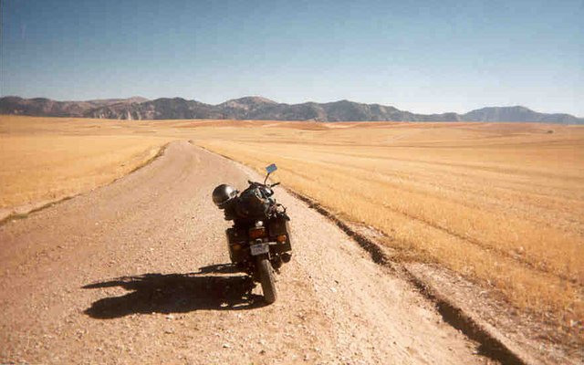
Now off the freeway, I was instead on hwy 287, one of the main routes to Yellowstone/Grand Tetons/Jackson, so there was a pretty good bit of tourist traffic. There was also major road work, with some serious delays. After a little off-raoding on a mostly-dirt road parallelling the highway (the old highway, in fact) ,I stopped at the gas station/store at Muddy Gap, one of those great old stores with a table in the middle, and a few locals and road workers drinking beer. The brewskis were too rich for my blood, but the microwave burrito was cheap and ample.
Truth to tell, I was damn glad to be back in the desert again! It was fully dark before I left the store, but the tempature was mild and the wind moderate. I rode through the desert night, tempted to keep going and make some time. But travel at night means you don't get to see where you've been, which was the whole reason for being here in the first place. Stopping at every historical marker, I learned that I was now travelling along the famous Oregon Trail, the old emmigrant route to the Pacific Northwest (and California). My last chance for a beer was the "town" of Jefferson City, which turned out to be just a combination store/bar, with no opther buildings in sight. And again, I was too cheap to spend the $2 for a can of Bud, I think I need to get my head examined. And/or get a job.
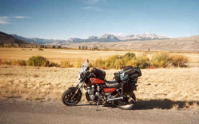
After about an hour of night riding, I turned off onto a major gravel road, removed my helmet (Wyoming, like Colorado, Idaho and Montana, doesn't require helmets), and looked for a nice campsite. (Actually, I routinely take my helmet off in these situations, legal or not.) About seven miles of riding revealed a passable spot in a lovely setting, as seen in the photo at the top of this page. Damn, it was good to be back in the open desert, rather than being crammed into some freezing forested Colorado mountain canyon.
In the morning, after the obligatory walk up one of those hills, it was back to the pavement. I was less than pleased to see another vehicle on the main gravel road, but then I guess no morning is perfect. Once on the highway, I pushed on, foregoing an opportunity to see the historical mining town of South Pass, some 20 heavily-touristed miles south down hwy 28.
Next stop, the amazing and large town of Lander. This county seat, just short of the Wind River Indian Reservation, really impressed me, and in fact may be the nicest looking town I've encountered in all of my bike travels. I'm not easy to please, but this town was the cat's meow. It felt like going back in time, maybe 10 or 20 years. There were long-haired local boys, and school kids, and retirees, and Indians. And pretty girls. It seemed clear that this town combined tourism, retirement communities, urban flight, and some kind of college, all prime ingredients for a prosperous and livable town. Wow.
After gas, the supermarket, and lunch in the park, it was on to the Wind River India Reservation. This was probably the most impressive rez I've ever seen, comparable to the Navajo Reservation down in Arizona. Most reservations seem to be either almost devoid of businesses, or devoid of Indians. This one had both, in large numbers. The tribal offices in Ft. Washakie were many and large, and I never even saw the biggest town, Riverton. Would that all reservations could be this happening. (A local village on the highway is named Crowheart, after some battle between the local Shoshone and neighboring Crow Indians. Can you guess how the heart fits in?)
I took a break at the excellent rest area in the center of the rez, and this is where the wind went from being a major nuisance to a serious problem. (This being reservation land, pulling off onto some dirt road and finding a quiet spot was not an option for an outsider.) The picnic tables were each behind concrete barriers, but the wind was still barely tolerable. Afternoon is when the wind blows hardest, and as it often does, it was coming out of the west, my direction of travel. Which meant that when I was riding along at 70MPH, it felt like 85 or 90MPH. Picture spending much time in a 90MPH wind, and you'll get an idea how my afternoon went.
While at the rest area, in between fighting with maps, I talked to Darryl from Price George, Bristish Columbia. (A major waypoint for my previous ill-fated trip to Alaska, actually.) He was mounted on an old Suzuki Cavalcade, which made him a fellow member of the Old Japanese Bike fraternity. He said that he rides at about 60MPH in windy conditions, and he mentioned that it was probably too late in the season for him to get back to Prince George, and he'd be leaving his bike somewhere in southern BC for the winter. Nice guy, with a great accent.
|
|
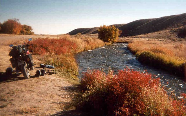
A farmer's field, with mountains in the distance, just west of Dubois, WY. Some 60 miles east of the Grand Tetons, the rolling desert hills of the middle part of the state give way to pine-covered mountains with bald rocky peaks. The town itself is nothing to write home about, just a pleasant little tourist town with ice cream, chocolate milk, and expensive confections.
Heading up into the mountains, and over Togwotee Pass, the wind finally abated and the road became wonderfully twisty. After doing a tiny bit off dirt-roading through the forest, I stopped above a deep gorge, and just happenned to notice the end of a nail sticking out of my rear tire. The tire seemed to have plenty of air left, so no big deal. Tubeless bias-ply motorcycle tires seem to often be able to hold air for days or weeks with a nail embedded, so long as you don't disturb the nail. So I kept an eye on it, and ended up opting to patch it the following afternoon.
Now I descended into the tourist hell that is Jackson Hole and the Grand Tetons, gateway to Yellowstone. At Moran Junction, the sign indicated that it would cost $20 to get my bike into Yellowstone, just as Darryl said. I decided to skip Yellowstone, and go around the south end of the Tetons via Jackson. With cars everywhere, and road work, and cops writing tickets, I just wanted to be elsewhere. But first, a little touristing!
For anyone has hasn't seen the Grand Tetons yet, you will understand why they're called "grand" once you see them. (Although my friend Edwin has suggested that the name is a little dated. Perhaps something more like The Bodacious Ta-Tas?) In fact, just as I was driving by, the sun was setting right over the peak of the tallest mountain. I stopped for a look, and the effect was striking. It looked a little like a solar eclipse, with the pointy peak eclipsing the sun, and truly weird light coming around the sides. And there's a mighty river (the very beginning of the Snake, I think) in a deep canyon, between the road and the Tetons. All in all, quite a sight, and I can see what all the exceitement is about. I wonder if Yellowstone is this grand also?
Just north of Jackson, there were a bunch of cars stopped, with dozens of people standing next to the road watching a bull moose. Wow, now that's a big animal! The mountains around Jackson itself didn't seem all that spectacular, certainly not compared to Telluride, but then I never saw the actual ski area, which I've heard is up the valley a ways. The town seemed kind of cool, and didn't rub me the wrong way as much as I expected it to. But the traffic was horrific, and in the first full darkness of the evening, dangerous for a biker. I spent an hour or two in two, not so much touristing as looking for services. While I never did find an open auto parts store (looking for a patch kit), I did find a gas station where I talked to the attendant for awhile, and a nice liqour store that sold me a can of beer and a little emergency "airline"-sized bottle of booze, which would come in handy two nights later, crossing from Montana to Idaho via an unexpectedly overnight gravel road.
In Jackson, I was struck again by the racial/cultural situation, when I saw a fair number of poor Mexicans (?) amidst the ski-resort splendor. Why is it that the rich urban dwellers, the ones who can most afford to pay a living wage, bring with them poor people to work for next to nothing? This isn't right.
Fleeing town through the dark and cold, I was in search of a little patch of ground to borrow for the night. This little heavenly plot, once discovered, would be across the state line in southern Idaho.
|
|
Well, this picture from Hwy 12 doesn't really say very much. So you'll have to take my word for it -- it was bitchin' beyond words.
|
|
gdfgfdgfdg
|
|
gdfgfdgfdg
|
[
previous |
next
]
[
Reno |
Nevada |
Utah |
Colorado |
Wyoming/South Idaho/Montana |
Idaho |
Oregon/California
]
|


